|
From an early age I
have had a
fascination for exploring and this has become a permanent feature in my
DNA as a mountaineer. In more recent years I have become a great
enthusiast of mountain biking trips and ski touring. For me, life is
too short to be able to visit all the places I'd like to know and
experience. After many backcountry ski trips to snow-covered
areas
all over the world my friend Roger and I began to look for something
different and unusual, a new and refreshing challenge. After bandying
around various proposals we finally agreed. At-Bash, a virtually
unknown name, as far as we were concerned, would be our chosen
destination.
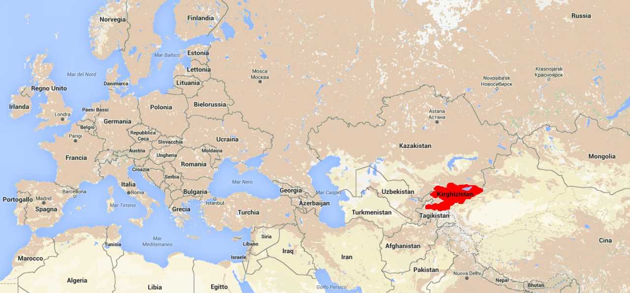
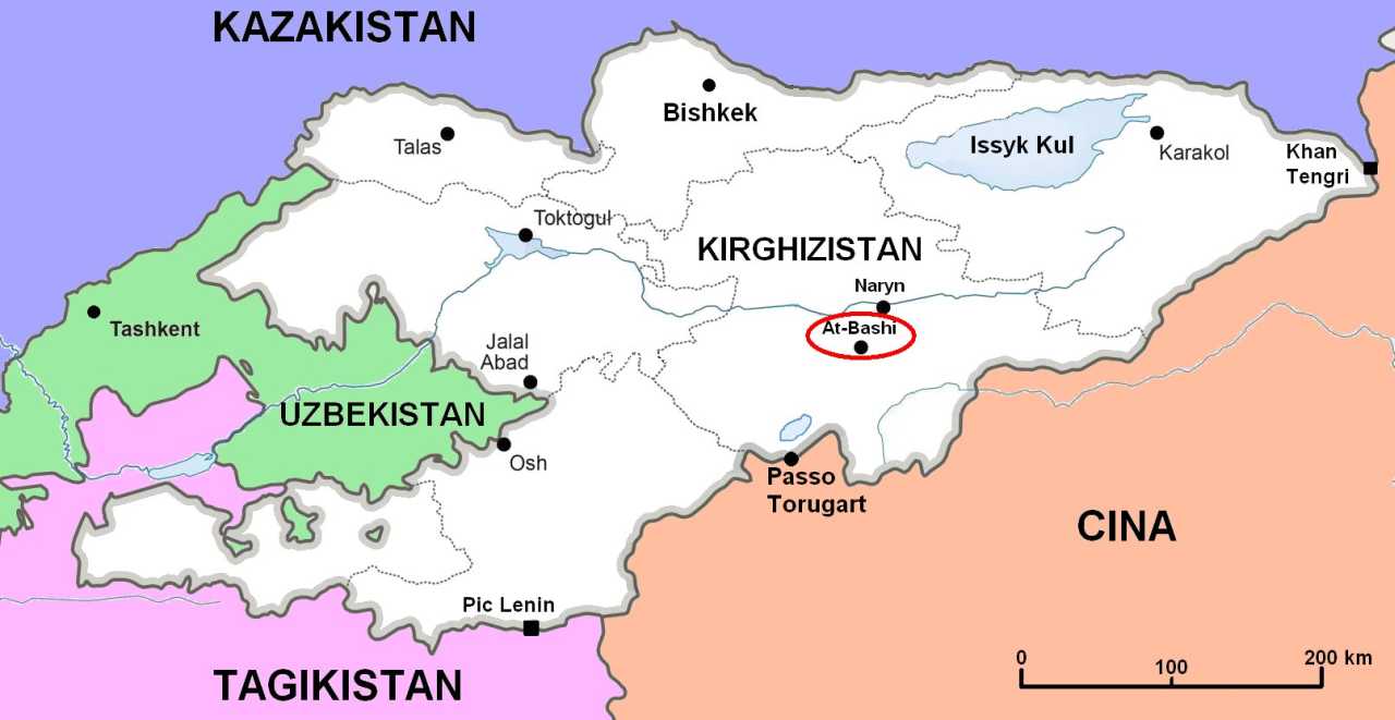
Kyrgyzstan is a mountainous country with a population of over five
million people. The language is written in Cyrillic but rooted in
Turkish like that of the neighboring population of Uighurs in China.
The Kyrgyz Republic was founded in 1990 after the collapse of the
Soviet Union. Like other former USSR states it has had an unsettled
time with authoritarian governments but now, according to our young
companion, Anarbek, a graduate who spent one year studying in the USA
and another in China, has given way to a mature democracy where the
current government can be challenged by the political left or right.
Some
of the mountains of this country, such as the Pic Lenin (7134m) on the
border with Tajikistan, or Khan Tangri (7010m) located where the
borders of Kyrgyzstan, Kazakhstan and China converge, are well known
and have been the focus of former expeditions. Most of the mountain
corrugation, known with the Chinese name of Tien Shan (Celestial
Mountain), is located in Kyrgyz territory. The very distinct range of
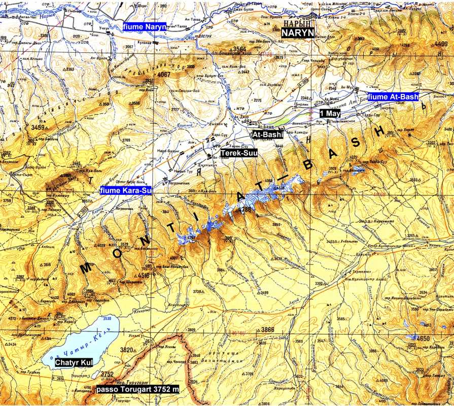
At-Bash, isolated by wide longitudinal valleys, which extend in the
ENE-WSW direction for about 100 km. with an average width of 25km and
engraved by very deep transverse valleys and mostly rocky peaks
reaching 4790m, is part of this corrugation. At-Bash, which in Kyrgyz
language means Horse Head, is also the name of the river that borders
the northern slopes and At-Bashi is the name of the largest town in the
valley, located at 2200m above sea level at the confluence of the
At-Bash and Kara-su (Black water) rivers. Here the wide valley provides
a huge inclined plane crossed by the important road linking Kyrgyzstan
with China through the Torugart Pass (3752m). The total population of
the dozen or so villages scattered throughout the valley is
approximately 15,000. The main activities of its inhabitants are
livestock farming (horses, goats, sheep and cattle) and stunted
agriculture due to the short duration of the summer season and the
continental climate where temperatures vary between -40 degrees in
winter and +40 degrees in summer. The river At-Bash is 180 km in
length. It flows through Naryn, the capital city of the region (Oblast).
Information
regarding the At-Bash is scanty. The only topographic maps are old
Russian military tablets with a scale 1:100,000. Digital contour lines
at 25 meter intervals, found on the Internet, are very useful for
installing on a GPS device. From a report available online and updated
in 2015, 'Mountaineering Regions of Kyrgyzstan', written by Vladimir
Komissarov, president of the Alpine Club of Kyrgyzstan (KAC), it
appears that the At-Bash mountains were explored for the first time in
2002 by the same Komissarov together with climbers of the Naryn region,
and then in 2007 and 2011, two British expeditions led respectively by
Pat Littlejohn and Andrew Vielkovsky focused on the valleys of Kensu
and Muzdabas on the southern slopes. Then ... the void. In this
circumscribed region there are more than 60 peaks of over 4000m, more
than 10 higher than 4500m, none of which has ever been climbed. Virgin
peaks. It is no surprise therefore that there were no ski
mountaineering approaches on these southern slopes and even less
surprising that there were no approaches on the north side. How could
we resist the lure of these wonderful mountains.
To feed my desire to revisit Kyrgyzstan there were also great memories
of a trip in the now distant 1998 when we climbed on the walls of the
valleys of Ak-Su[and Kara-Su. Even then our adventurous search for new
spaces in a country that had just gained independence from the USSR was
full of uncertainties and contradictions.
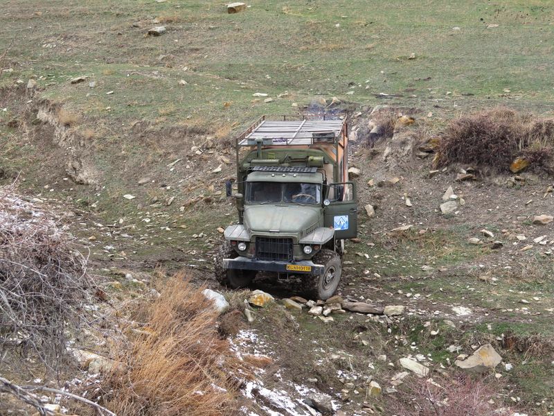
Our
first impression of the capital city Bishkek, which in Soviet times was
called Frunze from the surname of a Bolshevik revolutionary born there,
was very positive. It is very green, very clean, although the traffic,
which is a bit chaotic for a capital city, reflects the current
economic growth associated with Central Asia. Even though At-Bashi is
only 360km from Bishkek we spent 10 hours in the noisy and slow Ural
4320, an old van of military origin - 10 tons, six wheel drive, with a
Diesel 10,000cc engine, which runs 2km per litre at an average speed of
40km/hr on a paved road. We needed this off-road vehicle to access the
valleys. This is part of the charm of these trips in countries where
life is not all neatly planned and organised with rigid timetables and
reliable schedules, where the great virtue of patience leaves large and
unexpected spaces to fantasy and imagination. If we are able to endure
some discomfort, given our western lifestyle which attempts to cater to
our every desire, the satisfaction and wonderful memories reward us
beyond measure.
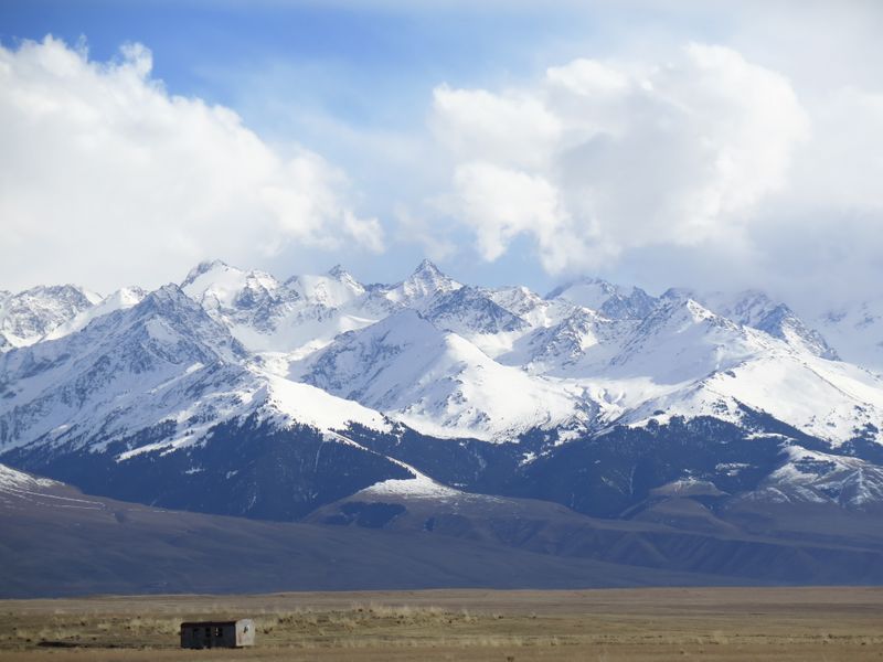
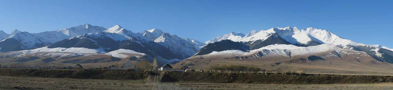
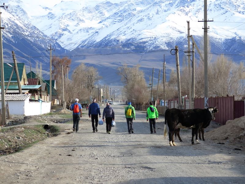
 Leaving
the green valley of Bishkek behind, the landscape becomes more severe:
great open spaces, mountains without names that appear in every
direction, some ups and downs between steep cliffs, wooded slopes
giving way to arid rolling hills as far as the eye can see, with all of
the erosive valleys adding to the beautiful tapestry of colours from
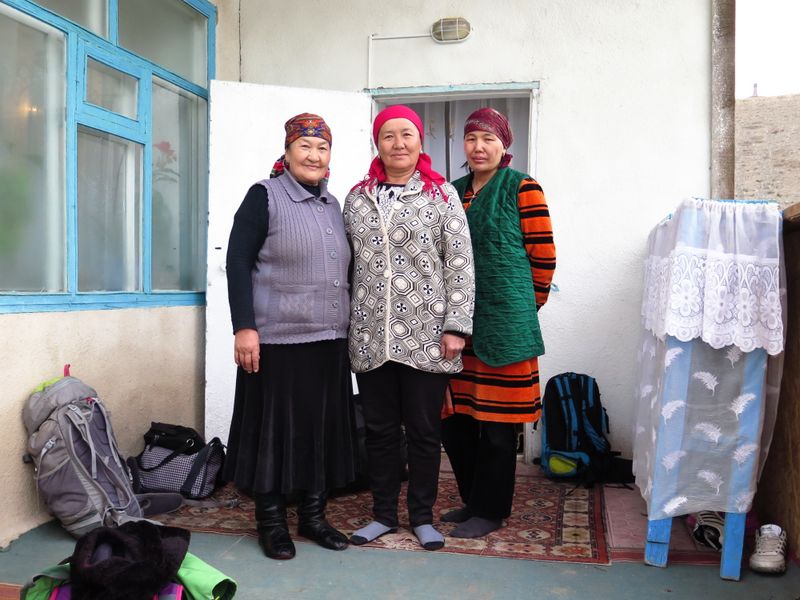
grey to greenish ochre then red. A bright sunset greets us in At-Bashi
where we are accommodated in the house of a matriarchal family (it
seems that everyone obeys the mother). We are given a friendly welcome
and led to large dormitories with walls covered with huge carpets, some
beds and mattresses on the floor. We are given hot food and introduced
to the local environment. The toilets are outside, as in the homes of
our (bis) grandparents, as is the shower that needs to be loaded with
water containers. For personal cleaning we also have access to the
nearby banya, the Russian-style excellent sauna. Although it is very
rustic, it is the place that will regenerate us after each day of
skiing.
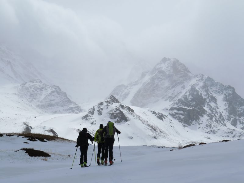
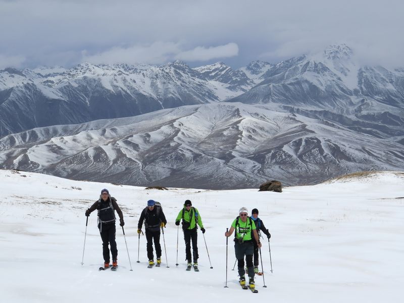
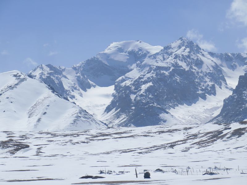
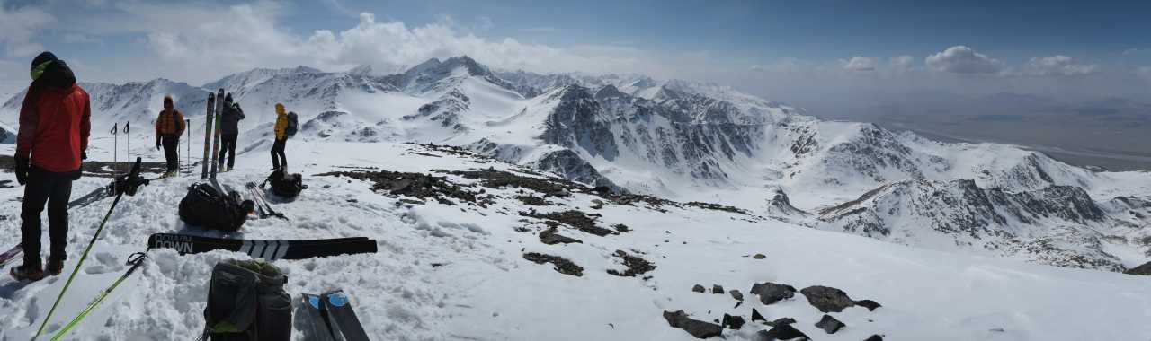
The
alarm at six in the morning begins the first day of ski mountaineering
activities. Finally the first sealskins are in place to help us tread
the snows in the At-Bash. The weather is ugly but we start with great
curiosity and enthusiasm as we set out for one of the two main valleys
facing the town which we think, according to our map, are named Acha
Kayindy (west) and Boskurba (east). However we must remember that the
scale of the Cyrillic maps is 1:100,000. As our cumbersome
but
effective Ural limps along bumpy tracks, dirt roads and dry grasslands
we note with a little concern that the lines on the map which we had
hoped would represent access roads are, in fact, only poor
tracks, passable only by horses or perhaps by motorbike. To complicate
matters further, snow is very scarce until you reach high altitudes.
The hands of the clock move round relentlessly and we need to make a
decision if we are
not to waste the day. Yesterday, when we were coming down from the
northern valley, we had noticed that in the easternmost part of the
chain the snow cover was better. We decided to change direction
completely and began to make our way towards the eastern valley until
we reached substantial snow cover. Here we stop Sasha, our driver, whom
we fondly named Gambadilegno (Woodleg) because of his sudden braking of
the vehicle. We attach the skins to our skis and start off in the
direction of a valley with no idea of the destination. Like all the
side valleys of the chain, it creeps southward through the mountains
that exceed 4000m, with the aim of accessing the interior and finding
some interesting elevations for skiing. Our intuition proves to be
correct. After some slightly sloped kilometres, finally steep slopes
surround us. From the GPS we understand that we are in a furrow leading
to a pass that gives access to a 4125m peak listed on the Russian map.
Unfortunately the weather is getting worse, the wind is strengthening
and visibility is poor. As it is getting late and we are alone without
external aid we decide not to venture beyond this point. Bringing a
makeshift stretcher to these endless valleys in the case of emergency
would take a long time. Reluctantly therefore, we do a turnabout.
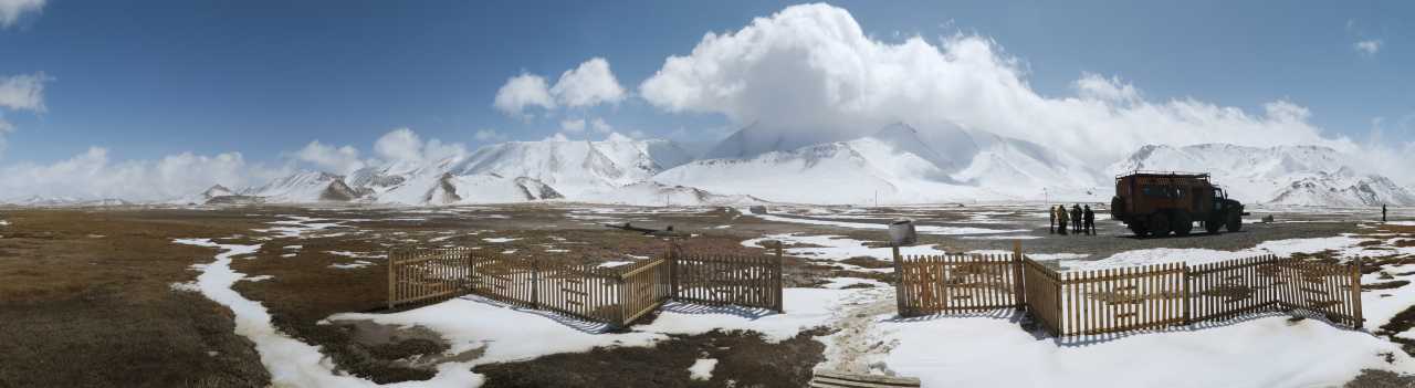
The
next day, Thursday April 7th, we decide to check the conditions at the
Torugart Pass, which we still hoped to visit. This area which borders
China, is a militarised zone and a special permit which we had already
procured, is necessary for entry. We had only travelled 160km from
At-Bashi but our Ural seemed to suffer altitude sickness more than we
do and it is already afternoon when we reach the place. Despite the
fact that we are now over 3500m there is very little snow. We are
attracted to the southern ridge but, as it happens, the Kyrgyz
government recently sold these slopes to China, from the valley floor
up to the ridges that marked the historical border. They immediately
erected a horrible double barbed-wire fence that prevents any access.
The ridges, now all Chinese, show mountains of over 5,000m, protected
by large ice seracs. On the opposite side there is a huge frozen lake,
the Chatyr-Kul, at 3530m with a surface measuring 180 square
kilometres, just visible because the road is 5 kilometres away. For me
the place has great appeal but I wonder if my friends can appreciate it
as I do. They seem more concerned about not finding snow in the coming
days. Some doubts begin to surface. However, after studying the maps
and digital contour lines that evening we agree that the valley
immediately west of the one we failed to access previously, may lead to
some beautiful snow-covered mountains. We know in which direction we
will point the Ural the following morning without wasting time.
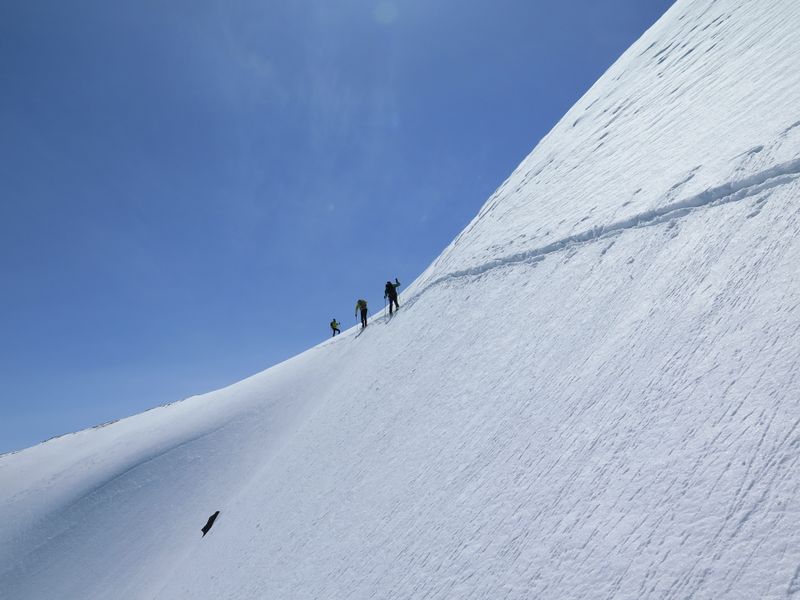
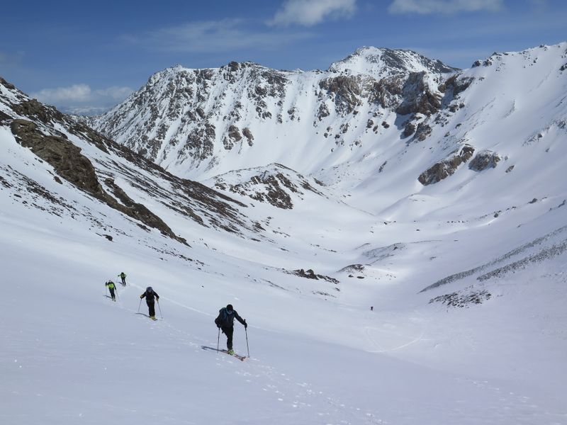 As
Friday 8th April dawns our adventure begins again with another long
valley to access followed by steep, rocky slopes that seem to bar the
way. Proceeding, a little by 'following our nose' and a
little by
GPS, we reach the
top of a steep slope. Finally an outlet appears at a pass at around
4000m. From here we can easily climb to a perfectly skiable peak quoted
on our Russian map as reaching 4,159.2m. Our morale soars as doubts
begin to fade. My mind flashes back to the summer of 1992 when with the
ever present Sonja and three bold young friends we ventured into a
Himalayan valley, without the aid of cartography, searching for some
unknown granite towers to climb. After four days of walking we turned
the corner of an unnamed glacier. There, resplendent before us, stood
the most magnificent granite spiers ever seen by human eyes. It was the
Miyar Valley. Although bad weather forced us to spend four days on a
small ledge a few pitches from the top, denying us the satisfaction of
reaching the summit, those visions, those feelings, the thrill of
discovering a valley, a whole group of mountains hitherto unknown but
which after our discovery became very famous for their climbing
quality, form a more intense and profound memory than many other
experiences. As
Friday 8th April dawns our adventure begins again with another long
valley to access followed by steep, rocky slopes that seem to bar the
way. Proceeding, a little by 'following our nose' and a
little by
GPS, we reach the
top of a steep slope. Finally an outlet appears at a pass at around
4000m. From here we can easily climb to a perfectly skiable peak quoted
on our Russian map as reaching 4,159.2m. Our morale soars as doubts
begin to fade. My mind flashes back to the summer of 1992 when with the
ever present Sonja and three bold young friends we ventured into a
Himalayan valley, without the aid of cartography, searching for some
unknown granite towers to climb. After four days of walking we turned
the corner of an unnamed glacier. There, resplendent before us, stood
the most magnificent granite spiers ever seen by human eyes. It was the
Miyar Valley. Although bad weather forced us to spend four days on a
small ledge a few pitches from the top, denying us the satisfaction of
reaching the summit, those visions, those feelings, the thrill of
discovering a valley, a whole group of mountains hitherto unknown but
which after our discovery became very famous for their climbing
quality, form a more intense and profound memory than many other
experiences. 
But
back to the new 'discovery', the At-Bash. The skiing from the peak
quoted as 4159.2m is on perfect firn snow with good slopes up to the
halfway point, then more gentle slopes and the long valley, with a
final surprise on the last meadows where the afternoon melting plunges
us up to our waist, and unexpectedly complicates the last
stretch. Despite the challenges we reach the Ural with smiles on our
faces, feeling super-motivated. The evening is celebrated, first with
beer, which in fact we always have on our table, and then the great
Kyrgyz cognac. Having reason to believe the mountain has never been
climbed before (Komissarov later confirms this), we begin to fantasise
about how to give it a name. Trying to match our Latin imaginations
with local place names we come up with Choku Chichi-bel
(cyrillic ЧОKУ
ЧИЧИБЭЛ, Choku="peak").
 Saturday
April 9th. The weather worsens and, while part of the group rests their
weary limbs, fatigued by the Choku Chichi-bel, the fiercest among us
decide to try to force an entry into the Acha Kayindy, the narrow
valley that cast us off on the first day. We have no ambition to climb
any 4000m peaks but we begin to ascend the first mountain with a bit of
snow, just to take a look around. From the point reached the first time
only a few days earlier, Woodleg pushes his terrible Ural along a bumpy
track through meadows and ridges up to the valley and then a little
further... maybe a little too far ... as the ten tons of screaming iron
begin to slip sideways on a narrow bend, coming to a merciful stop at
the edge of a cliff. Feeling like powerless spectators, we breathe a
sigh of relief. Fortunately we manage somehow to turn the vehicle and
get back on track. Finally we are able to start our walk. We shoulder
our skis for a long time because the path is low in the valley. At
first the snow is spread among cypress shrubs (local analogue of our
impassable dwarf pines) and we start to climb zigzag using techniques
dear to us on home terrain when snow is scarce. In the midst of a
snowfall we reach the first summit (3671m) of an endless ridge with a
series of peaks, some exceeding 4000m. However, given that access to
this valley is evidently more complex and lengthy than others and that
our time is limited, with only a few days left of our trip, we decide
to give up on the area. Our experiences so far have given us a better
understanding of the typical topography of these valleys and so, with
the help of the digital contour lines at 25m, more useful than the
Russian maps, we draw on the GPS a hypothetical line that could lead us
to a 4000m mountain the next day. Saturday
April 9th. The weather worsens and, while part of the group rests their
weary limbs, fatigued by the Choku Chichi-bel, the fiercest among us
decide to try to force an entry into the Acha Kayindy, the narrow
valley that cast us off on the first day. We have no ambition to climb
any 4000m peaks but we begin to ascend the first mountain with a bit of
snow, just to take a look around. From the point reached the first time
only a few days earlier, Woodleg pushes his terrible Ural along a bumpy
track through meadows and ridges up to the valley and then a little
further... maybe a little too far ... as the ten tons of screaming iron
begin to slip sideways on a narrow bend, coming to a merciful stop at
the edge of a cliff. Feeling like powerless spectators, we breathe a
sigh of relief. Fortunately we manage somehow to turn the vehicle and
get back on track. Finally we are able to start our walk. We shoulder
our skis for a long time because the path is low in the valley. At
first the snow is spread among cypress shrubs (local analogue of our
impassable dwarf pines) and we start to climb zigzag using techniques
dear to us on home terrain when snow is scarce. In the midst of a
snowfall we reach the first summit (3671m) of an endless ridge with a
series of peaks, some exceeding 4000m. However, given that access to
this valley is evidently more complex and lengthy than others and that
our time is limited, with only a few days left of our trip, we decide
to give up on the area. Our experiences so far have given us a better
understanding of the typical topography of these valleys and so, with
the help of the digital contour lines at 25m, more useful than the
Russian maps, we draw on the GPS a hypothetical line that could lead us
to a 4000m mountain the next day.
Sunday
April 10th. We head with Sasha-Woodleg from the village called 'May
1st' to the Tuyuk Bogoshti, a beautiful, wide valley that runs through
the whole group. This time we stop him before the mud gives us any
problems. We head off, still shouldering our skis, but not for long. As
we walk the first section on skins we are surprised to be joined by a
young shepherd on horseback who is definitely intrigued by our
equipment and intentions. 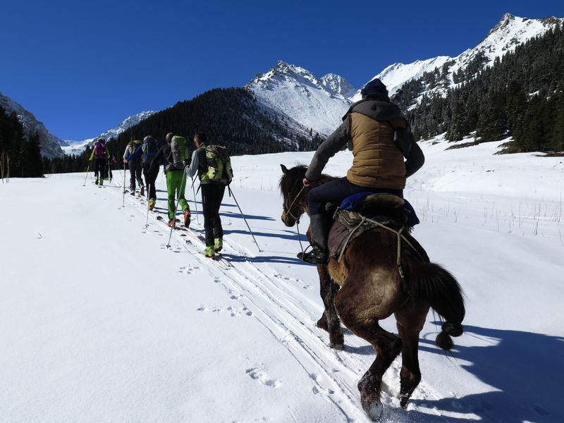 As
a 'folk figure' he immediately becomes the subject of our photos but
we, in turn, must have looked equally unusual to him, as he now
produces his mobile phone to catch pictures of us. We will no doubt end
up on some Kyrgyz social network as the 'strange visitors' of the day.
The main valley continues rising gently for a long way when suddenly
our 'theoretical' GPS track advises us to follow a rugged and narrow
valley/channel that branches off to the right and culminates in
perfectly snowy peaks with steep access. Our diligent shepherd however
encourages us to continue along the main groove and most members of the
group are inclined to take his advice. But the valley on the right
would allow us to gain altitude much faster. There is a bit of wavering
and indecision. In these moments democracy does not work and an
'executive' decision is required. Earning a moment of unpopularity I
head to the right on ground that is immediately narrow with a lot of
snow and impossible for the young horse to manage. While the horse
gives us an offended look as it turns around, the group follows me with
no objections. We pass easily the initial ravine thanks to the
accumulated snow from avalanches. The valley continues between very
steep side slopes, a mousetrap in wintertime, but now perfectly safe.
It continues toboggan style for several hundred meters to the base of
'our' mountain. The track prepared on the GPS is perfect...
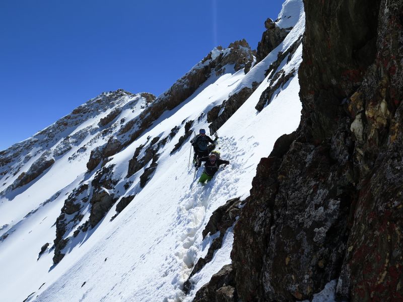
congratulations to Roger, our chief cartographer. We climb a ridge on
the right culminating in a 3954m crest, not a true summit but a kind of
hill. The rest of the group is happy and satisfied with the day's
achievements. Between us and the true summit there is a ridge, mostly
rocky and apparently not simple. I explore a little and find that down
on the right there is a ride so I remove my skis and continue walking. As
a 'folk figure' he immediately becomes the subject of our photos but
we, in turn, must have looked equally unusual to him, as he now
produces his mobile phone to catch pictures of us. We will no doubt end
up on some Kyrgyz social network as the 'strange visitors' of the day.
The main valley continues rising gently for a long way when suddenly
our 'theoretical' GPS track advises us to follow a rugged and narrow
valley/channel that branches off to the right and culminates in
perfectly snowy peaks with steep access. Our diligent shepherd however
encourages us to continue along the main groove and most members of the
group are inclined to take his advice. But the valley on the right
would allow us to gain altitude much faster. There is a bit of wavering
and indecision. In these moments democracy does not work and an
'executive' decision is required. Earning a moment of unpopularity I
head to the right on ground that is immediately narrow with a lot of
snow and impossible for the young horse to manage. While the horse
gives us an offended look as it turns around, the group follows me with
no objections. We pass easily the initial ravine thanks to the
accumulated snow from avalanches. The valley continues between very
steep side slopes, a mousetrap in wintertime, but now perfectly safe.
It continues toboggan style for several hundred meters to the base of
'our' mountain. The track prepared on the GPS is perfect...
congratulations to Roger, our chief cartographer. We climb a ridge on
the right culminating in a 3954m crest, not a true summit but a kind of
hill. The rest of the group is happy and satisfied with the day's
achievements. Between us and the true summit there is a ridge, mostly
rocky and apparently not simple. I explore a little and find that down
on the right there is a ride so I remove my skis and continue walking. 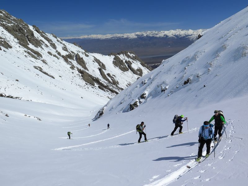 Three
of the group follow me. In a connecting portion between the rocks where
snow has drifted I sink down to my armpits. Fortunately Mirco, who
weighs 10k less than me, is able to pass the next three steps needed to
reach the rocks. From here we have no difficulty reaching the summit
where the altimeter marks 4016m. We hug and raise our arms to greet our
friends who remained on the crest. They cannot resist the temptation to
join us and as they in turn make the journey we share our moment of
stardom. We continue to celebrate our achievement that evening after
our descent on this perfect firn snow with a sauna, yet another toast
and another beautiful evening in good company, with the proposal to
dedicate the new mountain to the young Chiara, hence Choku Kiara (ЧОKУ
KИAРA). Three
of the group follow me. In a connecting portion between the rocks where
snow has drifted I sink down to my armpits. Fortunately Mirco, who
weighs 10k less than me, is able to pass the next three steps needed to
reach the rocks. From here we have no difficulty reaching the summit
where the altimeter marks 4016m. We hug and raise our arms to greet our
friends who remained on the crest. They cannot resist the temptation to
join us and as they in turn make the journey we share our moment of
stardom. We continue to celebrate our achievement that evening after
our descent on this perfect firn snow with a sauna, yet another toast
and another beautiful evening in good company, with the proposal to
dedicate the new mountain to the young Chiara, hence Choku Kiara (ЧОKУ
KИAРA).
Monday
11th. April... our last day. It would be nice to try the 4000m peak we
missed on the first day but with the accumulation of fatigue this might
prove too ambitious. Furthermore, the weather forecasts give a picture
of deteriorating weather conditions. Once on the road we decide to head
for a highly visible peak and try to track a hypothetical itinerary
using GPS. We cannot find the track that should lead us to our chosen
starting point. Eventually Sasha stops the vehicle at the beginning of
the forest where a very narrow valley begins. At least it is snowy. To
avoid shouldering our skis we climb this steep, dense forest. Once
again we are reminded of our home terrain. When we emerge from the wood
we are rewarded by the sight of a couple of valleys and right above us
a beautiful snow-covered peak (3650m), which we reach quite easily and
from which we serpentine down, again with satisfyingly firn snow. The
summit on which we had initially set our sights is on the continuation
of the ridge which is marked on the Russian map at 3806.6m but we are
happy and content with our achievements.
 We
are already at the end of a week of exhilarating experiences. Our
sincere thanks go to the family who hosted us and to Sasha
Woodleg,
our driver and Anarbek, our guide. The hospitality we received was
wonderful and the Kyrgyz people will remain in our memories with great
affection. After Patagonia '84, Karakorum '88, the Indian Himalayas '91
and '92 and Greenland '96 I thought my opportunities for discovery
could not be surpassed. But, as the world becomes increasingly
globalised, to discover and climb virgin mountains, explore unknown and
unmapped valleys and even baptise unnamed peaks is still possible. As a
rule I would not use the word 'exploratory' to describe our trips as I
feel it is often used out of turn by those travelling for the first
time in a place that has already been described and mapped. However,
our experiences here at At-Bash can only be described as a true 'ski
mountaineering exploration'. Who knows how many places like this still
exist hidden in the folds of the planet? Hopefully, the serendipity
which led us to the At-Bash will lead us to more discoveries in the
future, maybe even just by pointing the chance finger at the world
map! We
are already at the end of a week of exhilarating experiences. Our
sincere thanks go to the family who hosted us and to Sasha
Woodleg,
our driver and Anarbek, our guide. The hospitality we received was
wonderful and the Kyrgyz people will remain in our memories with great
affection. After Patagonia '84, Karakorum '88, the Indian Himalayas '91
and '92 and Greenland '96 I thought my opportunities for discovery
could not be surpassed. But, as the world becomes increasingly
globalised, to discover and climb virgin mountains, explore unknown and
unmapped valleys and even baptise unnamed peaks is still possible. As a
rule I would not use the word 'exploratory' to describe our trips as I
feel it is often used out of turn by those travelling for the first
time in a place that has already been described and mapped. However,
our experiences here at At-Bash can only be described as a true 'ski
mountaineering exploration'. Who knows how many places like this still
exist hidden in the folds of the planet? Hopefully, the serendipity
which led us to the At-Bash will lead us to more discoveries in the
future, maybe even just by pointing the chance finger at the world
map!
Paolo
Vitali, April 2016
Photos and maps by Ruggero Vaia and Paolo Vitali
Expedition
sponsored by CAI-SAT section of Cavalese
Skiers
of the group
Sonia Brambati, Franz Carrara, Gianni Corti, Mirco Gusmeroli, Denis
Ganz, Vigilio Ganz, Giulia Meregalli, Renato Pizzagalli, Fedorino
Salvadori, Franco Scotti, Ruggero Vaia, Paolo Vitali.
Ski tours
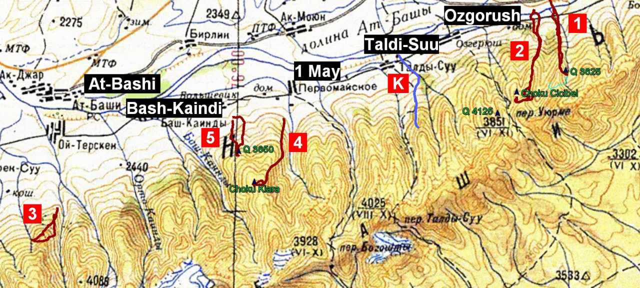
1) April 6 2016 – Q. 4125 m, valley Karaili Bulak
(tentative, till quote 3674 m)
2) April 8 2016 – Q. 4159,2 m, valley Sari Tal – proposed
name Choku Chichi-Bel (ЧОKУ ЧИЧИБЭЛ)
3) April 9 2016 – Q. 3671 m, valley Acha Kayindy
4) April 10 2016 – Q. 4016 m, valley Tuyuk Bogoshti – proposed name
Choku Kiara (ЧОKУ KИAРA)
5) Aprile 11 2016 – Q. 3650 m (lower-summit of Q. 3806.6 m), valley
Kichino Kek Djol
Practical info
 Periodo:
in winter, temperatures can reach -40 C (-40 F). However in April the
sun heats up very quickly and the snow at low altitude disappears
quickly. So, at the beginning of April you must consider the need for
shouldering skis at times. The end of March might be a better time
provided there have not been recent heavy snow falls, in which case you
must be very careful on the steep slopes. In the middle of winter it is
probably possible to ski with beautiful powdery snow but make do with
the outer peaks of the chain without going into the valleys. Periodo:
in winter, temperatures can reach -40 C (-40 F). However in April the
sun heats up very quickly and the snow at low altitude disappears
quickly. So, at the beginning of April you must consider the need for
shouldering skis at times. The end of March might be a better time
provided there have not been recent heavy snow falls, in which case you
must be very careful on the steep slopes. In the middle of winter it is
probably possible to ski with beautiful powdery snow but make do with
the outer peaks of the chain without going into the valleys.
Access:
By
air to the capital Bishkek. Currently the most frequent flights are
those of Turkish Airlines and Aeroflot. A good paved road covers the
distance of about 360km between Bishkek and At-Bashi. In At-Bash an
off-road vehicle is necessary to access the valleys.
Accomodation:
In At-Bashi the family of Mrs. Eva Aka Turunkan offers half-board
accommodation, ul.Arpa 25, tel. (+996) (0) 3534 23944, mobile (+996)
(0)773 105774.
Exchange
rate: in April 2016, the exchange rate was approximately
78 “Kyrgystani Som” for 1 €.
GPS:
very useful for orientation in the valleys and in case of bad weather.
The map of Kyrgyzstan is available on Openmtbmap.org and for a moderate
price, also the useful contour lines.
Maps:
the image-file of the Russian army maps are available on loadmap.net;
the best available scale is 1: 100,000 (1: 100k).
Telephone:
the best solution is to buy a local prepaid card, the cost of
international calls are much cheaper than any offer of European
operators, whose basic rates arrive at 6 € per minute. In the valleys
of course there is no signal, but there is in the towns and along all
roads.
Self
rescue:
Carefully consider the fact of being completely alone in the valleys;
in these places you cannot expect rapid external aid, so it is
necessary to have self-rescue equipment and provide for the possibility
of setting up an emergency stretcher.
|